For more than 55 years, ever since the first Water Resources Master Plan was formulated by IECO (1964), the policy makers and engineers have continued to seek more rigorous means of managing the water resources, floods and natural disasters in Bangladesh. Since then, numerous studies were conducted and millions of dollars were spent on hiring consultants. The most ambitious plan of all was the Flood Action Plan (1990-95) after the devastating floods in 1987 and 1988. The FAP study was a very elaborate undertaking. It involved 26 studies and pilot projects. The project was the first attempt to have a coordinated approach to flood management. However, the project was marred by weaknesses associated with poor institutional capacity and coordination, lack of involvement of stakeholders and inadequate assessment of ecological and environmental issues that resulted in a negative impact on the fisheries and aquatic lives. Consequently, after spending so much time and resources, the project was only partially implemented.
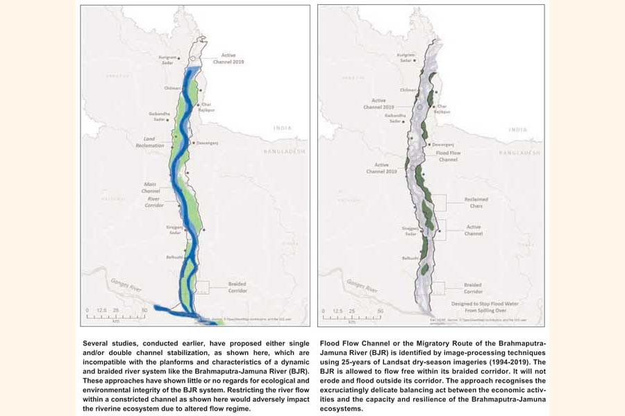
Since 1980s, several plans have been proposed to stabilize the Brahmaputra-Jamuna River (BJR). Following the experience of Yangtze the Lower Yellow River, the China Bangladesh Joint Expert Team or CBJET (1991), proposed a long-term plan for stabilisation of the Brahmaputra-Jamuna River based on the node and bend control system. Based on the suggestions made by the CBJET, the Flood Action Plan (FAP 1, 1994) proposed two-node control and bend control scheme for long-term stabilisation of the Brahmaputra-Jamuna River. Feasibility Study of Capital Dredging and Sustainable River Management in Bangladesh conducted by Bangladesh Water Development Board (BWDB) proposed a stabilized planform of the Jamuna River using a similar bend and node control concept. In 2013, the Main River Flood and Bank Erosion Risk Management Program (presently FRERMIP) offered somewhat different alternatives for stabilized planforms, such as, one major and one minor channel or two major channels in the lower part of the Jamuna River. Surprisingly, all these studies have proposed very similar ideas of either single and/or double channel stabilization, which is incompatible with the planforms and characteristics of a dynamic and braided river system like the Brahmaputra-Jamuna River. In addition, these approaches have shown little or no regards for ecological and environmental integrity of the Brahmaputra-Jamuna River system. Restricting the river flow within a constricted channel of the river would adversely impact the riverine ecosystem due to altered flow regime.
Innovative Approach
The objective of the present approach is to formulate an actionable management plan through understanding the past-present-future stage of the braided Barhamputra-Jamuna river system. It is designed to ensure safety by reducing hazards related to flooding/erosion and enhancing socio- economic-ecological benefits for long-term. The vision of this approach is, the Brahmaputra-Jamuna will be a free flowing river within its braided corridor, it will not erode and flood outside its corridor and it will provide optimized ecological, socio-economic and environmental services. It recognizes the excruciating delicate balancing act between the economic activities and the capacity and resilience of the Brahmaputra-Jamuna ecosystem.
The vision was conceived based on a fundamental premise that the wealth offield experiences and knowledge gained by the BWDB’s engineers and the academics and researchers at IWFM, BUET, give us an extraordinary edge to formulate an approach unmatched by any studies ever conducted on this most complex river system in the world. In addition, the ideas of engaging local expertise and knowledge are extremely cost-effective and time efficient. In recent years, Bangladesh engineers, academics and scientists have been increasingly recognized as world leaders in water resources and natural disaster management.
As the Bangladesh Delta Plan 2100 (BDP 2100) has pointed out that the major problem area of the previous studies was in project implementation due to weak institutional capacity and coordination, lack of involvement of stakeholders, inadequate attention to operations and maintenance and lack of ownership. Against the backdrop of these challenges and problems, the present methodology uniquely stands out among all the previous studies. This is an epic example of an extraordinary teamwork in the history of water and disaster management projects in Bangladesh. Both the BWDB and IWFM, BUET team members complimented their expertise and knowledge to formulate a hydro- morphologically most effective and ecologically robust river management system.
Managing Reclaimed Chars and Braided Corridor
Large braided river management requires the development of an integrated scientific approach that includes ecology, hydrology and river engineering. For a long-term sustainability of management plan and ecological benefits, two aspects are particularly relevant: one, maintaining the braided nature of the river and two, optimizing the ecosystem benefits with minimum interventions. Three options have been considered in the present approach considering low level, medium level and high-level interventions represented by Option 1, Option 2 and Option 3, respectively.
In Option 1 seven bank-attached Chars, which experienced the slightest encroachment by the flood flow channel (FFC) in the last 25 years, are considered to be reclaimed. In Option 2 additional two Chars are included with Option 1. The additional Chars in Option 2 experienced floods in the last 25 years and one of the channels inside the Char contained around 20% of flow during the extreme flood. In Option 3 two more mid-channel Chars will be intervened along with the Chars in Option 2. The additional Chars in Option 3 contain numerous channels. Therefore the ecosystem impairment is potentially high in the Option 3 scenarios. By implementing the Options 1, 2 and 3, the total lands to be reclaimed are 375 km2, 437 km2, and 644 km2, respectively. To protect the land from a 20-year return period flooding the average land elevation need to be raised by 3.5 m from the Low Water Level.
The river reaches of the Brahmaputra-Jamuna, flowing through Bangladesh, have a tendency of floodplain erosion of 16.5 to 50 km2/year in recent decades. Hence, as a long-term measure, it is recommended that the entire Braided Corridor (BC) be protected by flood protection embankments with provision for bank protection revetments, spurs and groins etc. Through the analysis of historical bank shifting process, flood flow channel dynamics and westward migration tendency, this study proposes the alignment of ‘Braided Corridor flood protection Embankment with bank protection Revetment’ (BCER). The total length of the BCER is 715 km (RB: 349 km, LB: 367 km). Among them approximately 130 km has already been protected by the existing structures constructed by the BWDB. The Brahmaputra Right Embankment (BRE) exists along 144 km length of the river starting from the downstream of Teesta River to the Bangabandhu Bridge for the protection against flood.
Intelligent Dredging
The Intelligent Dredging (ID) is defined asdredgingof an active and developing channels aided by modeling simulations and point cloud bathymetric data using LiDAR technology. Since the LiDARbased bathymetric data hasn’t been made available yet, an approach has been proposed to immediately dredge (immediate Intelligent Dredging, ID)four selected sections of the river reaches, about 40km in length, based on model simulations and available temporal planform satellite imageries. This method has been proposed to address the urgent need for improving conveying capacity along these reaches to immediately reduce the flood level and prevent it from erodingriverbanks and flood plains. However, the river-wise alignment of Long-term Intelligent Dredging (ID) should be assessed through numerical simulations and seasonal planform analysis based on point cloud data to be acquired through proposed LiDAR survey. Throughout the river a total of 450 km of ID alignment has been identified including the 40 km immediate dredging segments. Model sensitivity analysis with dredged bathymetry showed that the water level can be lowered up to 1.3 m during peak flow, which will mitigate the flood problems in the Brahmaputra-Jamuna river system. However, this dredging alignment must be confirmed after acquiring the point cloud LiDAR bathymetric data and series of model simulations to optimize the size and alignments of the dredging paths. Moreover, a strict monitoring system must be in place to monitor the ecological, bio-diversity and environmental health of the Brahmaputra-Jamuna river system. The purpose of implementing this monitoring system is to support an adaptive management practices to achieve a cost-effective and ecologically and environmentally sound river management system.
Observational and Monitoring System
A smart real-time observing system is considered in present approach for a successful and sustainable implementation of all the three Options for Char reclamation. Moreover, a deep understanding of the Brahmaputra-Jamuna river system using temporal and spatial observational data along with modeling simulations will help leverage this hydro-morphologically active and ecologically sensitive system to recover additional Chars and lands and generate more ecological services.
 The light detection and ranging (LiDAR) is a remote sensing system to measure ranges (variable distances) to the Earth. These light pulses, combined with other data recorded by the airborne system, generate precise, three-dimensional information about the shape of the Earth and its surface characteristics. LiDAR measures both the topographic and bathymetric data.
Eight water level monitoring stations (one primary and one backup per site) will be installed in four reaches of Brahmaputra-Jamuna River, two on both side of the river. The number of stations and its spatial distribution will be determined after a rigorous field study in the Brahmaputra-Jamuna River system. Each station will consist of a bank-mounted PVC tube fitted with an AquaTrak acoustic water level sensor powered by a single solar panel. Acquisition and cellular transmission of the recorded data is controlled by a data control board integrated into the sensor. These data will be extremely useful to monitor the flooding events and support early flood warning system they will provide invaluable insights for long-term planning, in combination with the modeling capabilities to be developed here.
Operational Modeling System
A robust and physics based three-dimensional hydrodynamic and sediment transport model, ECOMSED, used by the IWFM, BUET will continuously be configured and updated using the real-time data collected by the LiDAR. A computer algorithm will be developed to analyze the LiDAR generated high-resolution topographic and bathymetric data to produce dredging pathways along the river that will be configured into the modeling system. A series of iterative modeling exercises will be performed in order to determine optimized dredging paths that will maximize the conveyance capacity and produce a managed flood flow that will stay within its flood flow channels and will not overflow the Braided Corridor. After the optimized dredging paths are determined, the model will generate a detailed channel configurations including cross-sectional geometry and GPS coordinates of the dredging alignments in order to support field crews to dredge the riverbed with surgical precision.
It is important that the proposed real-time operational modeling system be integrated with other river systems dynamically connected to the Brahmaputra-Jamuna river, especially the Ganges-Padma, the Meghna river and the coastal ocean systems. An integrated modeling approach that will include other major rivers and the coastal systems is necessary to address the flooding problems in the Brahmaputra-Jamuna system.
It is important to note that the devastating floods occurred in 1988 and 1998, which were widely credited to the coincidence of flood peaks of both the Brahmaputra and the Ganges Rivers coupled with the southerly monsoon wind set-up in the Bay of Bengal. All the three forcing mechanisms appeared to significantly reduce the drainage capacity of the river systems causing devastating floods in the country. Therefore a comprehensive modeling approach should be taken to include the Ganges-Padma, the Meghna and the coastal Bay of Bengal for a better management of the flood in Brahmaputra-Jamuna river system. This modeling framework can be extended to include other river systems in the future to develop a nationwide comprehensive modeling framework to be called Bangladesh Delta Model (BDM). An operational BDM model will then be used as a tool for adaptive delta management (ADM) by the BWDB to manage the river systems of Bangladesh. The current modeling approach is envisioned to support the ADM practices outlined in Bangladesh Delta Plan 2100.
Conclusions
This study formulated an actionable management plan of the braided Brahmaputra-Jamuna River to mitigate the riverbank erosion and flooding while fostering social, economical and ecological benefits. This sustainable long-term plan ensures that it will be a free-flowing river within its braided corridor. The behaviour of the river planform was analyzed through literature review and extensive satellite images analyses. Numerical simulations were carried out to assess the impact of several interventions recommended by this study.
Three options have been considered in the present approach considering low level, medium level and high-level interventions represented by Option 1, Option 2 and Option 3, respectively.In Option 1, the bank attached Chars, which are not within the migratory route of the Flood Flow Channel will be stabilized and will not be flooded and eroded anymore. In Option 2,the bank attached chars, which are within the migratory route of the Flood Flow Channel will be stabilized and will not be flooded and eroded anymore along with the chars included in Option 1. In addition to chars in Option 1 and 2, a third option, Option 3 is considered where the mid-channel chars will be stabilized but these chars will be allowed to be flooded for now unless an adaptive management practice will be in place to monitor the ecological implications. A total of 375 km2, 437 km2, and 644 km2 will be reclaimed by implementing the Options 1, 2 and 3, respectively. Inter-connectivity will be established among the mid-channel chars through sustainable corridor management.
A new methodology called Intelligent Dredging has been introduced to dredge active and developing channels aided by modeling simulations and bathymetric data using LiDAR technology. A series of iterative modeling exercises are needed to determine optimised dredging paths and detailed channel configuration and alignments including GPS coordinates to support field crews to dredge riverbeds with surgical precision. An integrated modeling approach, which includes dynamically-connected major river and coastal systems, is necessary to address the flooding and erosion problems of the BJR. This modeling system may be configured in a nationwide comprehensive modeling framework called Bangladesh Delta Model (BDM), an essential tool for the BWDB to introduce adaptive river management.
Engr. Md. Mahfuzur Rahman and Dr. Shamal C. Das are from Bangladesh Water Development Board, Dhaka and Dr. Quamrul Ahsan, Dr. Anisul Haque, Dr. Munsur Rahman and Dr. Shampa are from the Institute of Water and Flood Management (IWFM), BUET, Dhaka.
