The severe cyclonic storm Fani has weakened further before reaching Bangladesh through south and south-western parts of the country.
The storm is likely to hit Khulna and its adjoining south and south-western parts of Bangladesh during Friday midnight to Saturday morning, a Bangladesh Meteorological Department (BMD) special bulletin said on Friday night, report BSS and Reuters.
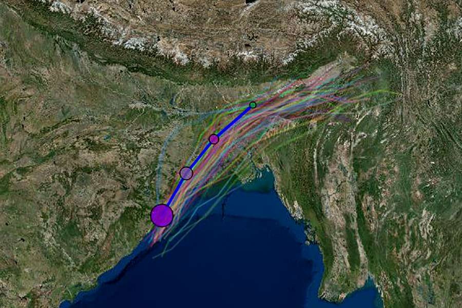
“The cyclonic storm has already crossed the Odisha coast of India and it is approaching towards the west Bengal and likely to hit Khulna and its adjoining areas of Bangladesh during Friday midnight to Sunday morning,” the BMD special bulletin said.
Meanwhile, India Meteorological Department chief KJ Ramesh on Friday said Cyclone Fani, the strongest storm to hit India since 2014, is weakening after barrelling into the eastern coastal state of Odisha.
‘After making landfall this morning, cyclone Fani has started weakening and it’s likely to enter Bangladesh by tomorrow evening,’ he said.
Earlier, BMD Director Shamsuddin Ahmed at a press briefing in city’s BMD office requested the people living in the low-lying areas to take refuge to cyclone shelters quickly as the country is now faced with the risk of the cyclone storm Fani.
The cyclone Fani will cross the country over the night and the low-lying areas of the coastal region also will be inundated by storm surge of 4-5 feet high above normal astronomical tide, said the official.
The very severe cyclonic storm over northwest bay and adjoining west-central bay moved slightly north-north-eastwards over the same area and was centred at 3pm on Friday about 445 km southwest of Mongla port, 495 km southwest of Payra port, 660 km west-southwest of Cox’s Bazar port and 660 km west-southwest of Chattogram port, it said.
The bulletin said Khulna and adjoining south-western coastal region of Bangladesh may experience the peripheral effect of the Fani.
Maximum sustained wind speed within 64 kms of the storm centre is about 120 Kph rising to 140 kph in gusts or squalls. Sea will remain very high near the cyclone Centre.
The met office asked maritime ports of Mongla and Payra to keep hoisting danger signal number seven and maritime port of Chattogram has been advised to hoist danger signal number six.
Coastal districts of Bhola, Borguna, Patuakhali, Barishal, Pirojpur, Jhalokathi, Bagherhat, Khulna, Satkhira and their offshore islands and chars come under danger signal number seven, while coastal districts of Chattogram, Noakhali, Laxmipur, Feni, Chandpur and their offshore islands and chars under danger signal number six, it said.
Maritime port of Cox’s Bazar has been advised to keep hoisting local warning signal number four.
Under the influence of the very severe cyclonic storm “Fani” and the new moon phase, the low-lying areas of the coastal districts of Chattogram, Noakhali, Laxmipur, Feni, Chandpur, Borguna, Bhola, Patuakhali, Barishal, Pirozpur, Jhalokathi, Bagherhat, Khulna, Satkhira and their offshore islands and chars are likely to be inundated by storm surge of 4-5 feet high above normal astronomical tide, the weather bulletin said.
The coastal districts of Chattogram, Noakhali, Laxmipur, Feni, Chandpur, Borguna, Patuakhali, Barishal, Bhola, Pirojpur, Jhalokathi, Bagerhat, Khulna, Satkhira and their offshore islands and chars may experience wind speed up to 80-100 kph in gusts or squalls with heavy to very heavy falls during the passage of the storm.
All fishing boats and trawlers over the North Bay and deep sea have been asked to remain in safe shelter till further notice.
